
| BCNBIRDS.ORG | PROJECT LINKS: | HOME | OVERVIEW | SPECIES TRENDS | CONCERN LIST | METHODS | FAQ'S | CONTACT US | |
The BCN Survey is a bird monitoring program that was implemented in the Chicago Wilderness region by the Bird Conservation Network. The Chicago Wilderness region historically incorporated eleven counties centered around the City of Chicago until 2007 when the region was enlarged to encompass regional watersheds and habitats beyond the previously defined political boundaries. It was also a response to the rapid expansion of development into the fringe counties in the Chicagoland area. The Chicago Wilderness region is unique from other adjacent counties and regions. Much of the land in the Chicago Wilderness region is either preserved land or land that is already heavily developed. Urban development radiates out a great distance in all directions from Lake Michigan and downtown Chicago. Farmland and larger tracts of unprotected natural areas dominate only in the fringe counties that comprise the Chicago Wilderness region. Because a large portion of the region is already developed, results from the BCN Survey are not particularly useful for examining how urban expansion is affecting bird populations in the area. The results presented here are most useful for examining how birds are faring in protected areas in and around the Chicago area and to serve as a guide for future planning. When viewing the results presented here, keep in mind that many of the preserved lands in the Chicago Wilderness region are being actively managed and restored by local forest preserve districts, state and national government agencies, and most notably by hundreds of volunteers working through programs like the Volunteer Stewardship Network. Restoration practices that affect our local breeding birds include (but are not limited to) buckthorn and honeysuckle removal, removal of invasive woody vegetation in grasslands, control of noxious herbaceous invasives such as reed canary grass and teasel, seed planting, controlled burning, and deer management. Many of the current initiatives are highlighted on the Habitat Project website run by Audubon - Chicago Region through cooperation with Chicago Wilderness. HISTORY Bird monitoring initiatives by citizen scientists have been active in the Chicago region for over two decades. In the past, a lack of standardized protocols and the daunting task of entering reams of data into digitized files has meant that much if not all of the information amassed over the past years remained largely inaccessible and difficult to analyze. In a 1998 effort - spearheaded by Judy Pollock, Alan Anderson, Terry Schilling, Lee Ramsey, and Elizabeth Sanders of the Bird Conservation Network (BCN), with major participation from a group of dedicated birders, scientists, land managers and conservationists including Jerry Garden (Chicago Audubon Society), Jerry Sullivan (Cook County Forest Preserve District), Doug Stotz (Field Museum), Stephen Packard (Audubon - Chicago Region) and Dan Niven (Illinois Natural History Survey) - a standardized protocol for bird monitoring was implemented which transformed monitoring practices and resolved central difficulties. Funding for this project has come from Chicago Wilderness, National Audubon Society, The Field Museum and the Illinois Department of Natural Resources Non-Game Wildlife Small Projects Fund. Instant publication and analysis of this data via the world wide web became a reality in 2001 when Cornell Lab of Ornithology's BirdSource teamed up with the BCN and the Field Museum to unveil a new web site. This site came about thanks to the efforts of Debby Moskovits and Doug Stotz (Field Museum), Terry Schilling, Lee Ramsey, Alan Anderson and Suzanne Checchia (BCN volunteers), Steve Kelling and Michael Brutvan (Cornell Lab of Ornithology) and Judy Pollock, Rickie White and Steve Frankel (Audubon-Chicago Region). In 2003, the database moved to a special BCN version of the eBird website, a nationwide side for data entry managed by Cornell Lab of Ornithology and Audubon. This move provided easier access to data for research purposes and casual observation, and also allowed monitors to easily enter their sightings at any of the predefined birding hot spots in the Chicagoland area. The primary purpose for the collection of this data was to provide land managers with information that would help guide their restoration practices at parks and preserves in the region. After amassing over 100,000 records and eight years of data, in 2004 BCN and Audubon - Chicago Region, thanks to a grant from Chicago Wilderness, set out to put the data to further use and investigate species trends in the region. The result was the first round of the BCN Survey Trends Analysis. Since then the BCN database has already grown to over 180,000 records. In 2007, with additional funding from Chicago Wilderness, a second round of more intensive analysis was implemented in an attempt to further refine previous results. DATA COVERAGE This analysis looked at data that followed the BCN Survey Point Count Protocol - a total of more than 50,000 records. A considerable 20% increase over our ‘04 analysis came from the inclusion of an additional 10,000 records from the Forest Preserve District of DuPage County database.
HABITAT COVERAGE Mike Ward of UIUC analyzed the area covered by the survey and attempted to assign habitats to each point based on aerial photographs and current land cover estimates. The species present at the point were also taken into consideration when assigning a habitat classification to a point. "The area within 100 m of Bird Conservation Network point counts encompasses 3,050 ha or 12 square miles (7535 acres). The habitat with the most point counts is upland forest, followed by grasslands and then savanna. Shrublands are also sampled at a high rate. Some of the habitats that are not covered are urban areas and agricultural fields. It is by no means because these habitats are not available, but rather they are avoided. COMPARISONS AND RESULTS Comparing the 2004 Analysis with the 2007 Analysis, the 2007 analysis refined the amount of error associated with the trends (pct. error and CI's) on average by 48%. This considerably large improvement can be attributed to the additional years and sources of data, omission of the start-up years of the analysis, and most importantly, the inclusion of habitat data in the analysis. Further inferences can be made from the habitat-specific trends that are also produced in the 2007 analysis. Declines in a number of species of considerable concern can also now be associated with specific habitat types - providing valuable additional information regarding possible reasons for their declines and future management priorities that can be established to stabilize those species. |
|||
|
||||||||
|
|
|||||||
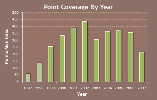 The BCN Survey now contains eleven years of data that follow Point Count protocols. Based on the first round of the trends analysis in 2004 and after initial analyses in 2007, it was determined that the trends could be refined considerably by removing data from the first two years of the analysis (1997-1998). Data was limited during these initial "start-up" years of the BCN Survey and a full level of participation from volunteers was not gained until 1999 (see graph). Since then, point coverage has been fairly consistent with an average coverage between 1999 and 2007 of 333.1 points per year. The drop in 2007 is due primarily to the fact that data from the FPD of DuPage Co. is only current through 2006 and some additional mailed data forms were still being entered by volunteers at the time the analysis began.
 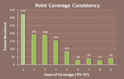 The consistency of coverage of points has also been a key issue associated with the quality of the analysis results. Of the about 1072 points monitored between 1999 and 2007, 323 were only monitored during one year. This data is not usable for the trends analysis and must be discarded. On average, points monitored between 1999 and 2007 were covered on average 3.99 years out of 9. Only 40 points were monitored during all nine years of the period selected for analysis. Point coverage for the trends analyses of individual species ranged from about 36% to 56% coverage with an average of 49.3% coverage. This is considered "acceptable" by many statisticians as the minimum percentage of data needed to draw accurate trends. Establishing more consistent site coverage is a primary goal of the BCN Survey based on these findings.
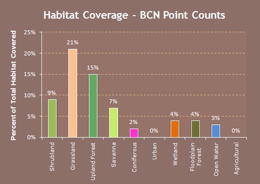 Bird Conservation Network points counts are distributed such that they have excellent coverage of upland forests, savanna/edge, grasslands, and shrublands. All of these habitats have well over 5% of the total habitat sampled ([in other words] the amount of habitat within in 100 m of a point count, accounts for greater than 5% of the total amount of this habitat available in northeast Illinois). For comparison, most systematic bird surveying studies (e.g. BBS) sample well under 1% of the total amount of area. One habitat in which the samples could easily be increased is floodplain forest. The BCN is not covering large areas in McHenry county where high-quality floodplain forest could be sampled improving the network's ability to monitor bird species that utilize this habitat. One habitat that was difficult to determine if it had been sampled was wetlands. Few point counts were actually in a wetland, but rather a point was done on the edge of a wetland. Because of this, it was sometimes hard to designate a point with a particular habitat. Furthermore, because there are several issues associated with wetlands such as the need for waders, canoes, and conspecific playbacks, BCN may not be suited to monitor wetland-dependent species. Additionally, the Illinois Department of Natural Resources, Northeast Illinois Wetland Bird Survey does a good job of sampling wetland-dependent birds in the area, and therefore BCN resources should be directed to monitoring forests, grasslands, savanna, and shrublands." (Ward 2007). A more detailed explanation of the habitat coverage can be found on the